Alert Section

Nature and Planning

Flintshire County Council must legally consider biodiversity in all planning decisions, requiring applicants to demonstrate how their proposals avoid harm, minimise impacts, and enhance local wildlife and habitats.

Flintshire County Council is legally required to take biodiversity into account when assessing planning applications. This obligation applies to all forms of development, whether major housing projects or minor home alterations.

If your proposal may impact local wildlife or natural habitats, you must demonstrate how biodiversity has been considered in your plans. This involves taking steps to prevent harm, minimising any unavoidable effects, and incorporating measures that enhance the natural environment.

This guidance helps applicants understand what ecological information may be needed when submitting planning applications for both minor and major developments.

Requirements can include information about protected species, habitats, biodiversity improvements, and green infrastructure. The amount of information needed will usually depend on the size and nature of the development.

However, even small developments can affect protected species. In these cases, specialist surveys and reports may be required to show how wildlife and habitats will be protected and enhanced.

Net Biodiversity Benefit

All development must deliver a Net Benefit for Biodiversity (NBB) and ecosystem resilience from the baseline state, which is proportionate to the scale and nature of the proposed development. 

Even if the biodiversity value is being maintained, there must still be a pro active approach to identify and secure enhancement through the design and implementation of the development.

Although, NBB is not required for an application to be valid, it is required prior to determination, and, therefore, its inclusion for consideration at an early stage is strongly advised (See Planning Policy Wales, Chapter 6).

For minor and householder applications:

For sites under 1000m2 which do not impact protected species, sites or habitats, a NBB plan and Green infrastructure Statement can be created using the Small Application NBB and GI form here.

The form includes a declaration that the selected measures will be implemented and evidenced.

For major applications: 

A detailed Net Biodiversity Benefit Plan will be required. The NBB Plan should clearly demonstrate how the stepwise approach to development has been followed. See the CIEEM Briefing paper here.

It should include: 

  • A table of existing habitats on site 
  • Habitats proposed post development. 
  • Management arrangements for the lifetime of the development.    

Green Infrastructure Statements

A Green Infrastructure Statement (GI Statement) describes how the green infrastructure or natural assets of a site have been incorporated into the development proposal. This includes features like trees, hedges, and Sustainable Urban Drainage Systems.

In accordance with Planning Policy Wales PPW12 a GI Statement is required for all developments to show that the development has net benefit for biodiversity and green infrastructure. It must be provided as part of the planning application and is not appropriate to seek retrospectively by way of a planning condition. 

For minor and householder applications:

For sites under 1000m2 which do not impact protected species, sites or habitats, a GI Statement and NBB plan can be created using the Small Application NBB and GI form here.

The form includes a declaration that the selected measures will be implemented and evidenced.  

For major applications: 

A detailed GI Statement will be required which should clearly demonstrate how the step-wise approach to development has been followed. 

It should include: 

  • Information from the ecology baseline surveys,
  • The tree survey carried out in accordance with the relevant current British Standard,
  • Landscaping,
  • Sustainable drainage documents

An example of a GI statement can be viewed here.

Considerations

It is important ecology is considered early when proposing or considering any development application. Early consideration can avoid delays and additional costs later in the process. 

The level and type of ecological information required to support planning applications is varied. The various reports and minimal requirements are discussed in detail in the 'Information for consultants' section below.

Not all species surveys are required for validation but there is an expectancy that they will be required prior to determination. 

Commissioning an ecologist

Any form of ecological assessment, and the surveys which inform them, should be undertaken by qualified and experienced professionals with an understanding of nature conservation legislation and planning. Persons undertaking surveys should also be able to demonstrate that they meet the minimum knowledge, skills and practical experience requirements as set out by Charted Institute of Ecology and Environmental Management (CIEEM).

The LPA does not certify or endorse any particular ecologist or environmental consultancy. However, when employing an ecologist, we advise that you are: 

  • Search online for a local ecologist who is a member of CIEEM (Chartered Institute of Ecology and Environmental Management), you are then hiring a verified professional whose skills and qualifications have been rigorously assessed, and if something doesn’t go as planned, you have the reassurance of their formal complaints process.
  • Be clear with what you require
  • Be open with all relevant information
  • Get a minimum of 3 quotes for the work

Natural Resources Wales provide guidance on commissioning an ecological survey here.

Preliminary Ecological Appraisal (PEA)

A Preliminary Ecological Appraisal (PEA) is the term used to describe an initial assessment of the ecological features present, and species potentially present within a site and its surrounding area. A PEA will be required for validation purposes in the situations listed in Figure 1.

A PEA comprises of a desk study and a habitat survey, followed by a written assessment. 

Figure 1 - When an ecological assessment is needed

The table below lists various examples for which a Preliminary Report or Preliminary Ecological Appraisal (PEA) is required at the validation stage.

Figure 1 - When an ecological assessment is needed
A PEA is required at the validation stage when an application affects any of the following:
Woodland, orchards, hedgerow or trees present on the application site or adjoining and affecting the application site.
Where areas of open green space (including scrub land) will be lost.
The conversion of barns and buildings.
Where watercourses and water bodies (including ponds, ditches, rivers) are impacted.
Any site or building containing a known protected species, or with a high likelihood of them being present (E.g. Near known records or a protected site with known presence)
The introduction of hard surfacing in the open countryside for driveways, footpaths etc.
Demolition of buildings / structures (including walls) and removal of roofs
Refurbishment of unoccupied dwellings
The clearance of scrub land.
Sites of nature conservation importance such as Protected Sites and Local Wildlife Sites (LWS). 
Where there is industrial archaeology - lime kilns, chimneys etc.
Infrastructure construction - roads, drainage schemes, electricity and telecommunications installations

Pre application site clearance

Planning Policy Wales states there should be no advantage gained from site clearance prior to an application being submitted and baseline survey work being adequately completed.

Where site clearance including the removal of hedgerows, trees, structures or scrub has occurred the PEA should (using best available evidence) establish a baseline prior to the clearance work. Evidence could include; photographs, historical aerials, street view, sales particulars, remaining adjacent habitats, records from previous PEAs or biological records from Cofnod.

Carrying out site clearance before an ecological assessment has been completed can result in the destruction of protected habitats or harm to legally protected wildlife. This may constitute a breach of wildlife legislation and could lead to enforcement action, project delays, financial penalties, or, in serious cases, police involvement and criminal investigation. 

Protected Species

The conclusions of the PEA should be used to inform which protected species surveys are required. An applicant submitting a planning application must confirm the presence or absence of protected species on site, and sometimes in the surrounding area.

The presence of a species protected under European or UK legislation, or under Section 7 of the Environment (Wales) Act 2016 is a material consideration when a planning authority is considering any proposal for development. 

A list of habitats and species protected under Section 7 can be found at Environment (Wales) Act - Wales Biodiversity Partnership.

If protected species are confirmed, an assessment of the likely impact of the development on the protected species may be required to inform the development management process, this should be carried out prior to validation.

Further information regarding protected species surveys can be found in the 'Information for consultants' section below.

Bats

Bats are protected under UK and European legislation. The legislation dictates that:

“Any structures or place which bats use for shelter or protection are protected from damage or destruction whether occupied or not.” 

This legislation has been incorporated into local and national planning policies. Local planning authorities (LPAs) have a legal obligation to assess whether bats are likely to be affected by a proposed development.

The presence of bats within the built environment relies on:

  • provision of roosting opportunities.
  • availability of foraging and commuting habitat; and
  • appropriate management / protection of existing roosts and areas.

Bat surveys

A Preliminary Bat Roost Assessment (PRA), also known as a scoping survey, is an initial survey conducted to evaluate the potential for bats to roost in a structure or on a site. This assessment is required where development activities might impact bats, (see Figure 2) and The PRA will determine if further, more detailed bat surveys are needed. 

If a structure/building is not easy to assess or has been disturbed, it is highly likely that further activity or emergence surveys will be required.

Figure 2 - When a Bat Preliminary Roost Assessment is needed

This trigger list indicates the situations where you are likely to encounter bats, and where the Planning Authority will require a developer to provide a bat survey prior to validation. 

Figure 2 - When a Bat Preliminary Roost Assessment is needed
1. Conversion, roof modification, demolition or removal of buildings
(including dwellings, hotels, schools, hospitals, churches, commercial premises & derelict buildings) which are: 
Agricultural buildings (e.g. farmhouses, barns and outbuildings) which have elements of brick or stone construction and/or with exposed wooden beams.
Any buildings and structures within 250m of woodland, parkland, rivers, or other wetlands.
Buildings with weather boarding and/or hanging tiles.
Any building with a suitable south facing roof over bitumen felt with significant stripping and modification proposed.
2. Development affecting built structures: 
Tunnels, mines, kilns, ice-houses, adits, military fortifications, air raid shelters, cellars, natural rock faces.
Similar underground ducts and structures; unused industrial chimneys that are unlined and brick/stone construction.
Bridge structures, aqueducts and viaducts (especially over water and wet ground). 
3. External lighting or floodlighting of: 
Churches and listed buildings, green space (e.g. sports pitches) within 100m of woodland, water, field hedgerows or lines of trees with connectivity to woodland or water; 
Any building meeting the criteria listed in (1) above. 
4. Felling, removal, topping or lopping of: 
Trees in woodland.
Trees in field hedgerows and/or lines of trees connecting woodland or water bodies.
Mature trees that are older than 100 years, especially veteran and ancient trees
Where an applicant believes that a bat survey is not proportionate, despite falling into one of the above categories, a series of internal and external site photos should be submitted with a justification outlining why the survey is not considered necessary

Figure 3 - Flow chart showing the validation and decision-making process with regard to ecological information

Figure 3 ENG
Flow chart for ecology reports and decision making through the planning process.

Detailed Ecological Information for Consultants

Preliminary Ecological Appraisal (PEA)

A Preliminary Ecological Appraisal (PEA) is the term used to describe an initial assessment of the ecological features present, and species potentially present within a site and its surrounding area. A PEA will be required for validation purposes in the situations listed in Figure 1 which can be found in the 'What information and surveys are required for an application to be valid?' section above.

A PEA comprises of a desk study and a habitat survey, followed by a written assessment. 

Objectives of a PEA: 

  • Identify the likely ecological constraints associated with a project taking into account the projects extent and nature
  • Identify any mitigation measures likely to be required, taking into account the ‘Mitigation Hierarchy’ and ‘Step-Wise Approach’
  • Identify opportunities to deliver ecological enhancements on-site at an early stage of the development process, maximising biodiversity benefits within the site and minimising the need for off-site compensation, which should only be considered as a last resort.
  • Identify any additional ecological surveys that may be required

Contents of a PEA:

In most cases, it is expected that a PEA would include:

  1. Identification of any designated nature conservation sites (statutory and non-statutory) that could be affected by the project. 
  2. Mapping of the habitat types present to provide a visual representation of the land within and adjacent to the site boundaries. 
  3. Assessment of the likely importance of the habitats present, determining (as far as possible within the constraints of the site visit(s) undertaken) whether there are any protected or priority habitats present, which could be affected by the project. Any limitations in relation to this must be clearly stated.
  4. Assessment of the likely presence of protected and priority species, which could be affected by the proposed development, and confirmation of the presence or absence of any such species, as far as possible within the constraints of the site visit(s) and the time of the year they were undertaken. 
  5. Identification of any ecological constraints to the client and relevant members of the project team (Based on information gathered in bullets 1-4). This will allow likely significant effects to be avoided wherever possible through careful scheme design and ensure that the likely requirements for possible mitigation and licensing are understood (based upon the level of information known about the project at the time of the assessment). 
  6. A list of further ecological surveys likely to be required to inform a proposal, together with their appropriate scope, methodology and timing (Based on information gathered in bullets 1-5)
  7. Identification of opportunities for ecological enhancement or Net Biodiversity Benefit.

Desk study or background data search

A desk study or background data search should be the first step when carrying out a PEA and, where necessary, should include a data search from the local record centre for North Wales, Cofnod. 

Cofnod is the only organisation providing information on Local Wildlife Sites (LWS) and will ensure consultants consider all species that could be potentially present.  

Data Map Wales can be consulted for certain data sets including Statutory Protected Sites and Ancient Woodland. 

Please note: Reports using data from The National Biodiversity Network (NBN) will not be accepted because they are not for commercial use.  

MAGIC mapping does not include licensing, Local Wildlife Site information or other habitat information for Wales because it relates to England only.

Habitat Survey

Where relevant, the habitat survey within a PEA should include the following:

  1. A plan of the habitat types present using a published and recognised habitat classification. 
  2. An assessment of the likely presence of protected or priority species, and where relevant, an assessment of the likely importance of the habitat features affected by the proposed development for such species, with reference to available desk study information. This should include:
    • Plants 
    • Fungi 
    • Terrestrial and aquatic invertebrates 
    • Fish (where relevant, based on an assessment of any watercourses and water bodies present); 
    • Amphibians (including both breeding and terrestrial habitat) 
    • Reptiles 
    • Breeding, wintering and migratory birds 
    • Bats (including potential roost sites, and foraging and commuting habitats/features) 
    • Other protected or priority mammal species, as relevant 
  3. Mapping of any stands of non-native invasive plant species. 
  4. Recording of any incidental sightings of priority or protected species, or field signs of such species.
  5. Recommended measures to provide a Net Benefit for Biodiversity.

Protected Species Surveys

Bats

Bat surveys must be completed in accordance with the following national guidance.

Bat Surveys for Professional Ecologists: Good Practice Guidelines 4th edition - Guidance for professionals - Bat Conservation Trust.

If a bat survey demonstrates that bats and/or a known roost are likely to be affected by the proposed development and planning permission is to be granted, full information will be required prior to any decision, including complete details of mitigation, monitoring, long-term maintenance plans and compliance. The level of detail in the submission should be similar to that required in a European Protected Species Licence (EPSL). The LPA will place conditions and an informative on any application and it is the responsibility of the applicant to have an EPSL before work commences. Criminal proceedings may take place if the EPSL is not applied for and complied with in full.

If a PEA concludes that development is likely to affect bat foraging and/or commuting habitat, linear features such as tree lines should be retained, and compensatory planting should be considered wherever possible. This should be reflected in the Green Infrastructure Statement. Conditions regarding bat friendly lighting will be imposed on any permission.

Lighting and Bats

Lighting submissions should be compliant with The Institution of Lighting Professionals (ILP) latest practical guidance on considering the impact upon bats when designing lighting schemes in August 2023: Bats and Artificial Lighting in the UK' Guidance Note GN 08 / 23

Any conditions referring to a bat friendly lighting scheme should be accompanied by a lighting contour plan. That is a horizontal illuminance contour plan which is prepared by a suitably experienced and competent lighting professional (Member of the Institution of Lighting Professionals (ILP), Chartered Institution of Building Services Engineers (CIBSE), Society of Light and Lighting (SLL) or similar to ensure competency) using an appropriate software package to model ‘Day 1’, extent of light spill from the proposed, retained and, possibly, existing luminaires. The various buffer zone widths and illuminance limits which have been agreed with the ecologist can then be overlaid to determine if any further mitigation is necessary. 

Great Crested Newts

North East Wales is a stronghold for Great Crested Newt (GCN). The species relies on both aquatic and terrestrial habitat for breeding, foraging and commuting. They are found in the borough over a wide variety of habitats. 

Where development is within 300m of suitable aquatic habitat presence or absence surveys may be required.  This should be determined in the conclusions of the PEA. 

Until further up-to-date guidance is released, The Great Crested Newt Mitigation Guidelines (2001) and The Great Crested Newt Conservation Handbook should be used as references. The Supplementary Planning Guidance  provides some specific mitigation requirements for sites around the Deeside and  Buckley Newt Sites and Halkyn Mountain Special Areas of Conservation.

Habitat Suitability Index (HSI)

HSI is a rapid assessment tool and shown to be ineffective at determining GCN presence within Flintshire County Council. Poor HSI scores will not necessarily mean GCN are absent from a site.

eDNA

Use of eDNA is just another survey technique, it is not a mandatory requirement. We will accept this technique to determine GCN presence or absence if samples are undertaken in strict accordance with the published technical advice note and they are collected by a suitably trained and experienced licensed GCN surveyor. Samples can be taken from 15th April to 30th June.

  • This technique will not provide population size class assessments.
  • Should a population size class assessment be required for the proposed development/project then the applicant will require 6 survey visits using conventional survey methods, in accordance with current recommendations within the Great Crested Newt Mitigation Guidelines, (2001).

Otter

Where applications affect or are within close proximity to a watercourse an otter survey may be required.  This will be determined by the PEA.

Dormouse

There are small pockets of dormouse recorded in Flintshire. The requirement to carry out a presence or absence survey is dependent upon the presence of historical records and the nature of the application. This will be determined by the PEA.

Badger

Badgers are common in the county, they can be found across all habitats and can move quickly onto sites if the habitat and feeding opportunities are available. It is common for pre-commencement checks to form part of a planning condition. For the benefit of developer, these should be carried out by a qualified ecologist and as close to commencement as possible. 

Reptiles

There are five species of reptile found in Flintshire, across habitats such as grassland, open mosaic, scrub, heathland and wetland. They are particularly prevalent on brownfield sites and quarries. Due to the restricted survey period and weather dependency, planning surveys in advance is essential. This will be determined by the PEA.

Survey Timings

For certain species and habitats, surveys can be carried out at any time of year, but for other species, particular times of year are required to give the most reliable results, as indicated in Figure 4.

  • Surveys conducted outside of optimal times below may be unreliable. For certain species (e.g. Great Crested Newt) surveys over the winter period are unlikely to yield any useful information. Similarly negative results gained outside the optimal period should not be interpreted as absence of a species and further survey work maybe required during the optimal survey season. This is especially important where existing surveys and records show the species has been found previously on site or in the surrounding area. An application may not be valid until survey information is gathered from an optimum time of year.
  • Species surveys are also very weather dependent so it may be necessary to delay a survey or to carry out more than one survey if the weather is not suitable, E.g. heavy rain is not good for surveying for otters, as it washes away their spraint (droppings). Likewise bat surveys carried out in wet or cold weather may not yield accurate results.
  • Absence of evidence of a species does not necessarily mean that the species is not there, nor that its habitat is not protected (e.g. a bat roost is protected whether any bats are present or not).
  • Local Biological / Environmental Records Centre may have useful existing information and records.

Figure 4 - Ecological Survey Seasons

Figure 4 shows a calendar of survey timings for different species and habitats
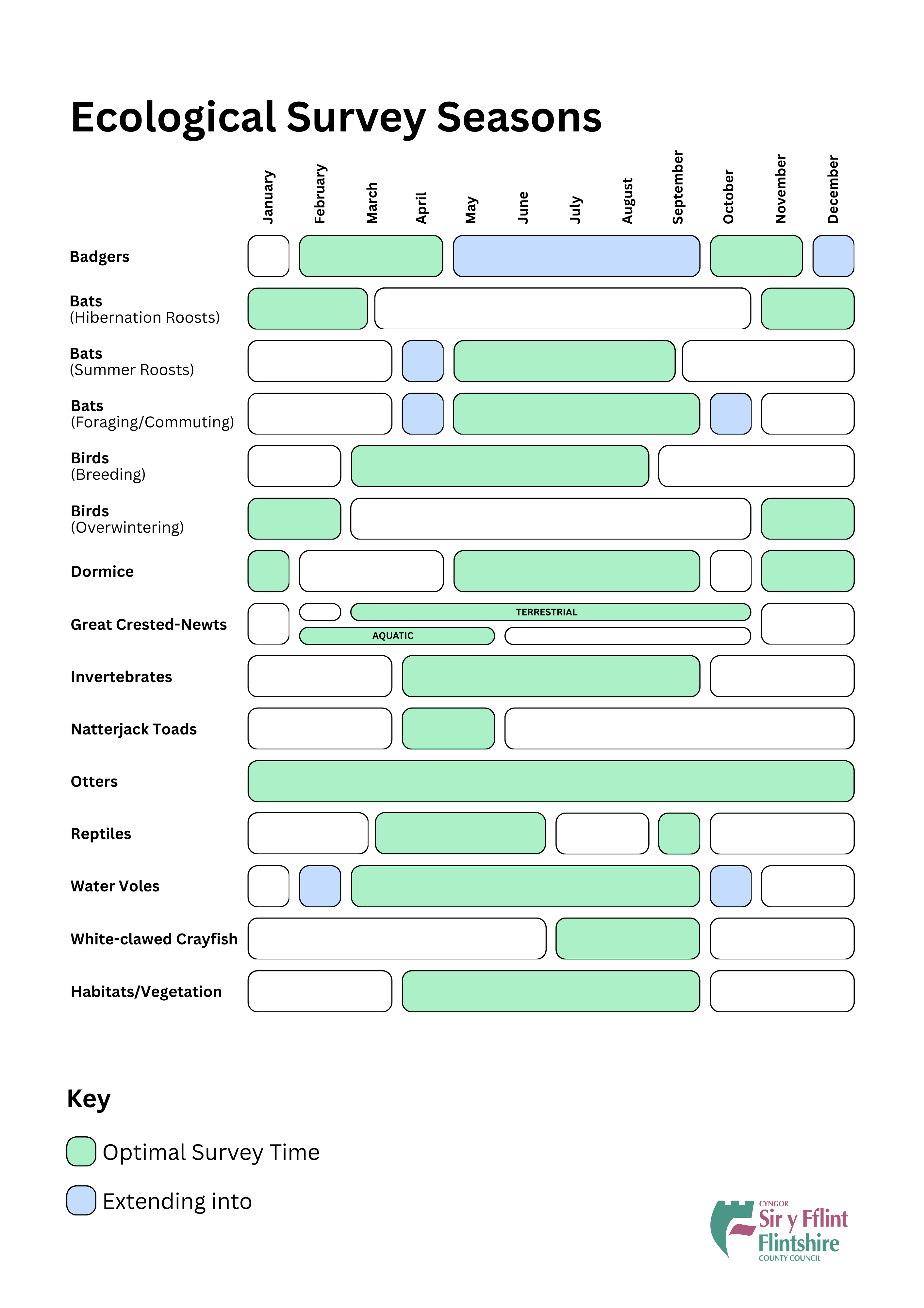
Figure 4 ENG
Calendar of survey timings for different species and habitats.

Phosphates and Development

Many Welsh Special Area of Conservation (SAC) rivers have excess phosphate, mainly resulting from wastewater and agriculture. High phosphate levels cause eutrophication (enrichment) which harms protected habitats and species. When granting planning permission planning authorities are required to ensure phosphate loads do not further increase.

Part of the County of Flintshire drains into the River Dee and Bala Lake SAC. Due to the river failing to meet set environmental targets, any application draining into the SAC will need to comply with advice given by Natural Resources Wales (NRW). Additional information regarding drainage arrangements may need to be supplied to the Local Planning Authority (LPA) at the application stage.

Further detail can be found here.